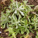
This year’s geology field trip went further back in time than its predecessors – to the Upper Jurassic of 160 million years ago, when Cothill near Abingdon lay under warm, clear, shallow sub-tropical seas. Lesley Dunlop led the well-attended walk on the chilly morning of Saturday 7th February, starting from the car park of BBOWT’s Dry Sandford Pit Nature Reserve. The group set out along the edge of the reserve, where Stinking Hellebore flowers were seen, then continued through Cothill village, before turning onto the muddy track which led towards Cothill National Nature Reserve. Cothill Fen is one of the most species-rich lowland calcareous fen systems in the UK, with a rich assemblage of plants and invertebrates. The track continued into woodland and crossed the first of a number of difficult stiles. There were a series of fishponds beside the path, probably lined with clay in order to retain their water in the sandy soil. Towards the top of the chain of ponds, the botanists interpreted the abundant Great Horsetail on the banks as an indication of a spring line. The walk continued along a footpath across a field of turnips, where Germander Speedwell and Shepherd’s-purse were in flower and Marsh Cudweed was also seen. The footpath led through a strip of woodland, crossed the Sandford Brook and emerged onto a lane in Dry Sandford village. The stone in a cottage wall was a mixture of limestone and sandstone, with traces of shells and crystals of calcite on the limestone sections.
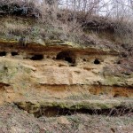
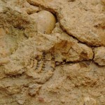
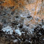
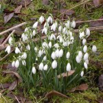
The final part of the walk was in Dry Sandford Pit Nature Reserve. Different layers of sand and limestone could be seen on the exposed quarry walls. At the top was the Coral Rag, made up of small patches of fossilised coral reef in oolitic limestone. Below was a thick layer of pale marl, a soft calcareous sand. Next came alternating bands of limestone and sandstone, with the harder limestone layers protruding. The sandy layers had many small holes, made by mining bees and wasps. The limestone layers are called the Trigonia beds, after a fossil mollusc. A broken-off lump of limestone had the clear imprint of a ribbed triangular shell, which Lesley said was a Trigonia fossil. The different layers were evidence of changing sea levels – the sandy layers were laid down close to shore, while the limestone was laid down in deeper water. The limestone was formed from the fossilised remains of creatures such as sea urchins and molluscs. At the base of the cliff and out in the wet area in the centre of the quarry were large slabs of limestone, called doggers. The walk continued along a path round the interior of the quarry. At the far side was a dammed-up section of stream. Interaction between organic material and the iron-rich water gave orange deposits and the surface of the water had an oily sheen. On the walk back to the car park, flowering snowdrops were seen and a woodpecker was heard drumming in the distance.
Pictures by Rob Stallard and Jan Haseler