
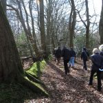
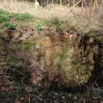
On a fine sunny day 10 members joined Lesley Dunlop to explore the geology of Nettlebed Common. Lesley explained that on most of the Common the sands and clays of the Lambeth Group overlie the chalk bedrock. These remnants of a more extensive deposit were deposited about 60 million years ago in a warm estuary. They provided raw materials for the brick and pottery industry and there are many ponds in the former clay diggings formed because the impermeable clay prevents rainwater from draining into the chalk below. The Lambeth Group sands and clays are acidic so in more sandy areas the acid drainage /groundwater can pass through fissures in the chalk beneath and eventually dissolve enough to produce a sinkhole. Our figure of 8 route started along The Green, after a short distance we turned into the wood to view an example of this. A large 4m x 5m sinkhole had opened up about 3 years ago after a wet January. The boundary of the chalk layer was visible, and some bricks on one side suggested the hole may have opened up previously and been filled. Other sinkholes have appeared in local gardens. We then headed back and up Chapel Lane; green alkanet, gorse and primroses were in flower. Continuing along the track we saw some of the ponds left after clay extraction for the brickworks, and recently cleared of overhanging vegetation. Our first Brimstone of the day was spotted. Heading west we crossed Mill Road and saw sand and clay workings alongside the track.
After crossing the Recreation Ground we reached Priest Hill, an area with Nettlebed gravels and interglacial organic silts which is a SSSI for its geological significance. Lesley explained that this was a chalk landscape up to 80 million (m) years ago; and there is no chalk younger than this here although the end of the Cretaceous period was 65m years ago – there is a 20m year gap. This may be because this area had been uplifted above sea level. The exposed surface would then have been subject to weathering. The Lambeth Beds were deposited in the estuarine environment which followed. There is no other geological record in this area for another 50m years. The gravel deposits are dated at 2m years ago. Although there was glaciation as far south as Aylesbury there was no ice cover here, just permafrost, so the water passing over the surface would have caused some erosion. During glacial periods there is more surface run off, and the rivers cut down through overlying layers. Braided river systems were formed where the river regularly switched channels and deposited gravel. The Nettlebed gravel is the oldest associated with the Thames. It is probably not a terrace deposit, but possibly a gravel deposit across an area which was preserved because it dropped into a sink hole – other small gravel deposits exist locally. Subsequently the drainage pattern of the Thames changed and covered the Midlands. Then the terraces nearer the Thames were established with more local material.
We followed the path to an area near a large beech tree where the 2m year old gravel (deposit) is exposed. The older rounded stones are flints which have been exposed on a shore line. The action of river water is not sufficiently intense to round off flints. A broken pebble showed a 2-3mm worked layer. We also saw some small creamy white quartz stones, they originate in veins of igneous rock, probably granite in SW England or Brittany. In the Triassic period erosion caused by flash floods washed pebble beds to the Midlands. These quartzite Bunter pebbles were carried down by the river systems and deposited in younger gravels here. Walking on we left the gravels and moved onto the Lambeth Beds again, with muddy patches due to bands of clay in the sand layers. We passed an open area previously used as a scout camp where heather was growing in the acid soil and mosses which prefer acid conditions were identified. Hard fern was seen on the sides of a large pit.
Report by Julia Cooper and Rob Stallard

Pictures by Rob Stallard