Undeterred by falling sleet and a temperature of 3C, 17 members turned out on the morning of Saturday 13 February for another of Lesley Dunlop’s excellent geology walks. The walk started from Chapel Farm, Leckhampstead, where the base of one of the farm buildings had been constructed from local flint and sarsen stone. The route led south-eastwards over first Clay-with-flints, then Chalk. A Skylark sang from above the fields and a Yellowhammer called from a distant hedge. The track dropped down into a typically asymmetric dry valley, with one side steeper than the other. The valley was formed by run-off in colder conditions, when the Chalk bedrock was frozen. Trees marked out the alluvial deposits in the bottom of the valley. The track climbed up out of the dry valley and continued southwards. Three hares ran across the fields. Lesley pointed out circular depressions which marked out areas where the underlying chalk had been dissolved by acid groundwater. These were concentrated towards the top of the field near the boundary with sandy Lambeth Group (formerly known as Reading Beds) deposits. Rounded flints beside the path, smoothed by wave action on a beach, contrasted with the angular flints which had been seen earlier in the walk. The gradient of the path increased slightly as the bedrock went forward 30 million years from the chalk, laid down about 85 million years ago, to the Lambeth Group, laid down about 55 million years ago. The buildings of North Heath Farm were on the Lambeth Group deposits.
At this point, in better weather conditions, there would have been a good view of the Hampshire Downs to the south, the southern boundary of the syncline, or downward fold of the bedrock, which was formed in the Alpine mountain-building time, when the African plate collided with the European plate. The next track headed north-eastwards back across the fields towards the dry valley. A Kestrel was spotted here. Beyond the valley, a herd of about 15 Fallow Deer were seen, first in the wood at the side of the track and then in the open fields beyond. The final track headed back towards Chapel Farm up a much shallower dry valley. The soil at the bottom was ‘head’, formed by soil creep down the valley sides. At the side of the path was a pile of enormous sarsen stones which had been moved by the farmer from the adjacent field. Lesley explained that these were lumps of hard sandstone, formed by localised patchy cementation of the Tertiary sands which formerly covered the Chalk. Fossil root holes indicate that this cementation occurred near the surface. Evaporation of ground water in the warm Tertiary period would have concentrated dissolved silica to the point where locally it crystallised out, cementing the sand grains together. Subsequent erosion of the uncemented bulk of the Tertiary beds left these hardened blocks behind as sarsen stones.
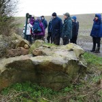

Pictures by Laurie Haseler